| |
|
The
land borders of Antarctica – the South Pole
|
|
|
|
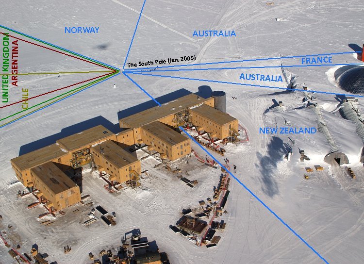
Eleven
boundary lines meet in one single point at only one place in the world
– the Geographic South Pole located near the Amundsen-Scott South Pole Station.
The approximate boundary drawn on the photo above is according to the
pole's situation of January 2005. The UK, France, Australia, New Zealand and Norway all recognize each others' claims, which do not overlap.
About 50 Antarctic Treaty member states have signed the treaty which in
its Article 4 says "the treaty does not recognize, dispute, nor
establish territorial sovereignty claims; no new claims shall be
asserted while the treaty is in force". |
|

|
The Geographic South Pole is marked by a small sign and a stake in the ice pack, which are repositioned each year on New Year's Day to compensate for the movement of the
ice. The sign records the respective dates that Roald Amundsen and Robert F. Scott reached the Pole, followed by a short quotation from each man and gives the elevation as 2,835 m (9,301
ft). (Source: Wikipedia.) |
|

|
Seven
countries; Norway (20°W – 44°38E), Australia (44°38'E – 136°11'E
and 142°2'E –160°E), France (136°11'E – 142°2'E), New Zealand
(160°E – 150°W), Chile (90°W – 53°W), United Kingdom of Great
Britain and Northern Ireland (80°W – 20°W) and Argentina (74°W –
25°W) have territorial claims on parts of the Antarctida. The three
last claims are overlapping each other. It is a common misunderstanding
that the northern and southern borders of Norway's claim are not officially defined,
but they span from the South Pole to 60° south as the other
sectors. |
|

|
The
South Pole is the only undecapoint in the world, as eleven
borderlines meet in one single point. These boundaries are the only dry
borderlines which in relations to building and infrastructure on the map constantly are
changing because the South Pole ice
sheet is
constantly moving (about 9 metres per year).The geographic pole on the
map above was at January 2005. (Click on the image for a high
resolution image.) (Image:
Wikipedia) |
|

|
|
One part of Antarctida,
Marie Byrd Land, and some islands near the coast are not claimed by any
country. (This is not unique – there is another territory (in Africa)
which neither is claimed by any state.) (Image: Wikipedia) |
 |
| Norway
and Australia, two countries with their mainlands located on the opposite
side of the globe of each other, have both territories on the Antarctida
which share an about 2460 km long common boundary (AUNO). Norway's
"capital" in Queen Maud Land is Troll Station (year-round
run),
while Australia's "capital" in the Australian Antarctic Division is
Davis Station.
(Image: Wikipedia) |
This page was last time updated on 22.11.10
|