| The Disputed Border
between Portugal and Spain in the Minho River |
|
|
| The
Minho River (Miño) rises in Serra de Meira, in Galiza (Galicia, Spain),
and it meets the Atlantic Ocean between A Guarda (Galiza) and Caminha
(Portugal). Its total extension is 300 km. In the last 75 km it forms the
border between the Portuguese Province of Minho and the Spanish Autonomous
Region of Galiza. |
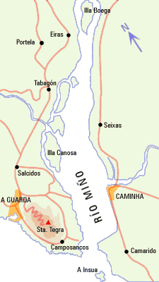
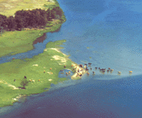
This shows the river "seen" from the ocean to upriver. The
Ínsua island, at the mouth, is no doubt Portuguese territory. The Boega
island, on top, is refered
to in Portuguese documents.
(Source: http://www.riasbaixas.org/html/es/15/1/014-1.shtml) |
| Concerning
the zone of the Minho River, the Treaty of Limits of 29 September 1864
established the border between Portugal and Spain in the deepest points of
the riverbed (thalweg?). This solution would only have some usefulness in
case the river it dried up - something unlikely in the zone of the
estuary, since the medium limit of penetration of the tidewater goes up to
35 km from the river mouth. |
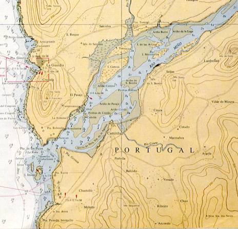
Here you have some islands not shown in picture above. The border line
is not shown. The smaller island to
the west of Ínsua is called Ínsua Nova (New
Ínsua); I guess it belongs to Portugal too. Ínsua is now also called
Ínsua Velha (Old Ínsua).
(Source: http://194.65.82.105/Estuarios/MenusEstuarios/Descri%C3%A7%C3%A3o/descricao_Minho.htm
) |
|
| In 1906 it was
made an addendum to the treaty, dividing among the two countries the
waters of the river and respective small islands in the zone of the
estuary, in agreement with the margins then existent. |

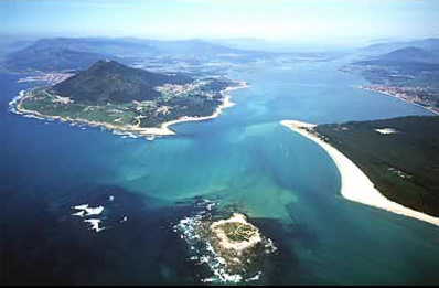
Another view of the
mouth of Minho River.
(Source: http://www.manorhouses.com/ports/caminha.htm
) |
|
| Along
the years the configuration of the river shifted, mainly from middle of
the XX century, due to the dams constructed upriver. It increased the
sedimentation, there were formed new sandbanks, appeared some new islands
and another disappeared. There was erosion in the riverbanks and there
were islands that moved northwards. The dynamics of the rivers was again
altered, since 1994, when begun the periodic dredging to allow the sailing
of a new ferry between Caminha and O Pasaxe. |
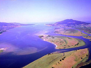
In this photo of the
river mouth you see Ínsua and the sands of Ínsua Nova. Please notice
the conic Sta. Tecla mountain in
the Galician side.
(Source: http://www.erin.utoronto.ca/~eparra/profile/Other%20links.htm
) |
|
| Nowadays
the official Portuguese and Spanish maps no longer agree on the imaginary
line of 1906 in the middle of the river, originating a dispute among the
two countries for the ownership of the small islands of the estuary.
According to the Spaniards, Portugal claims islands that are now on the
north side of the original border line of 1906. |
This shows the Minho estuary
and the river mouth seen from the Galician side towards the ocean. Sta.
Tecla is in the background at right.
Source: http://es.geocities.com/ec3cec/page10.htm |
|
| The
solution of this problem of sovereignty of the Minho islands has been
postponed by the Portuguese and Spanish authorities. In the meanwhile,
some islands have been used for farming and cattle rising. Other are
tourist attractions for people who demand the riverside for leisure
purposes. The Grande island, with 110,000 m2, seems to be the main
litigation point between Portugal and Spain. The Galician municipality of
Salvaterra de Miño intends to establish a nature park there. |

I guess this is seen from Sta. Tecla towards
upriver.
Source: http://www.crtvg.es/ingles/natureza/priportadaflash.htm
) |
|
|
As above.
Source: http://www.crtvg.es/ingles/natureza/priportadaflash.htm
) |
|
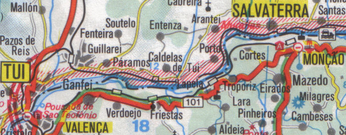
Between Tui and Monção, is my scan from RV Reise- und Verkehrsverlag
GmbH; scale 1:300.000. Here the border line is not
clearly set (this is a road
map), but most islands seem to be on Portuguese side. The Grande
island, referred in the text, is in this area. |
|
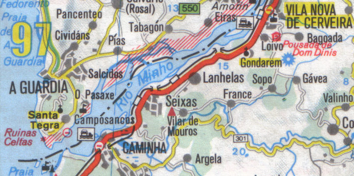
Between Vila Nova de Cerveira and the sea, is also my scan from RV
Reise- und Verkehrsverlag GmbH; scale 1:300.000. Again,
the border line is not clearly set and it is
even over some islands. Ínsua islands are on Portuguese
side, correctly. |
|
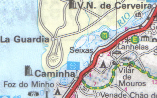
The Minho estuary, is my scan from the road map of the Automóvel Club de
Portugal; scale 1:350.000. The border line is not shown, but all the
islands are on Portuguese side. Perhaps because it is a Portuguese map. |
|