 | |
|
Jan
S. Krogh's Geosite: France
– Italy (FRIT) Border
France
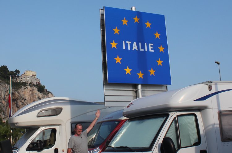
shares a 488 km with Italy. This European Union sign of Italy is in
French-languaged, most likely because it actually is situated on the French
side of the border,
at the former Menton border station.
The Treaty of Paris with Italy
(1947) was the last general revision of a French frontier.
 |
In 1947, in the Treaty of Paris, France gained about 700 km², in five extensions of the national territory in the départements of Alpes-Maritimes, Hautes-Alpes and Savoie: |
|
annexation of the Tende Valley, which had remained Italian when the County of Nice became French in 1860. The border here now follows the main crest of the Alps. The département of Alpes-Maritimes saw its area extended by 560 km².
 |
the upper valley of the Roya, that is the communes of Tende and La Brigue, |
|
the hamlets of Libre, Piène-Basse and Piène-Haute (commune of Breil-sur-Roya), |
|
the hamlet of Mollières (commune of Valdeblore), |
|
the upper valleys of the Vésubie and the Tinée; |
|
|
displacement by several kilometres of the Italian border in the Mont-Cenis massif, thereby increasing French territory by 81.8 km², on the commune of Lanslebourg, Savoie. From this time on, the frontier has no longer followed the line of the crest but is on the slope of the Italian side. The Mont-Cenis Dam and reservoir, subsequently constructed on its slopes, is thus in France though on the Italian side of the ridge. |
|
annexation of the summit of Mont Thabor and its eastern slopes, notably the upper basin of the Vallée étroite (narrow valley), in the commune of Névache, Hautes-Alpes (47 km²). |
|
annexation of Mont Chaberton (17.1 km²), in the commune of Montgenèvre (Hautes-Alpes), notably of an Italian fort, destroyed by French forces at the opening of the Second World War. |
|
annexation of the western part of the Little St. Bernard Pass following the watershed. (3.22 km²), to the benefit of the commune of Séez, Savoie.
It should be noted that though the Paris Treaty settled disputes on these five points in the line of the border, in the area of the summits of Mont Blanc and Mont Blanc de Courmayeur, questions remain open. |
Source:
Wikipedia.
Sources
and links
-
Skyscrapercity.com
- photos of locations of the pre-1947 France-Italy boundary: http://www.skyscrapercity.com/showpost.php?p=68414937&postcount=3766
|
|
This page was last time updated on 04.03.12
|