| Border marker no. |
Position (approx.) |
Pre-WWII marker
no. |
LTLV 1927 Treaty Page |
LTLV 1927 Map Page |
Con-crete Markers 1930 |
Con-crete Markers 20151 |
Place names |
Present Crossing Point2 |
Historical photos |
Remarks |
| LTLV-0001 |
56° 04' 09"N 21° 03' 55"E |
1 |
1 |
1 |
LT+LV |
LT |
Būtingė, LT /
Nida, LV |
No |
Yes |
Lithuanian pre-WWII border marker (without
insignia). |
| LTLV-0011-0012 |
56° 04' 38"N 21° 07' 21"E |
1 — 2 |
1 |
2 |
|
|
Būtingė, LT /
Rucava, LV |
Yes
 |
Yes |
|
| LTLV-0129-0131 |
56° 13' 19"N 21° 20' 50"E |
16 — 17 |
83 |
7 |
|
|
Lenkimai, LT /
Lankuti, LV |
Yes  |
|
|
| LTLV-0146 |
56° 14' 27"N 21° 25' 54"E |
21 |
91 |
8 |
|
|
Luknės, LT /
Lukne, LV |
Yes |
|
|
| LTLV-0167 |
56° 17' 11"N 21° 29' 19"E |
33 |
93 |
10 |
|
|
Gurstiškė, LT /
Sedviņi LV |
Yes |
|
Old concrete pole without inscription
located on Latvian side. |
| LTLV-0193-0194 |
56° 17' 36"N 21° 31' 58"E |
40 — 41 |
102 |
11 |
LT+LV |
(LT) |
Kulai, LT / Ozoli, LV |
Former railway crossing point |
|
|
| LTLV-0197-0198 |
56° 17' 45"N 21° 32' 20"E |
41 |
102 |
11 |
|
|
Skuodas, LT /
Priekule, LV |
Yes |
|
|
| LTLV-0276 |
56° 19' 45"N 21° 44' 27"E |
52 |
183 |
14 |
|
|
Gėsalai, LT / Aizviki, LV |
Yes |
|
|
| LTLV-0354-0355 |
56° 22' 54"N 21° 57' 22"E |
75 — 76 |
219 |
18 |
|
|
Strėliškai, LT /
Vainode, LV |
Yes |
|
|
| LTLV-0365-0367 |
56° 23' 43"N 21° 58' 49"E |
80 — 81 |
221 |
18 |
LT+LV |
LT+LV |
Lūšis, LT /
Vainode, LV |
Former railway crossing point |
|
|
| LTLV-0435-0436 |
56° 25' 42"N 22° 06' 53"E |
97 |
256 |
20 |
|
|
Pikeliai, LT / Pikelmuiža, LV |
Yes |
|
|
| LTLV-0443-0444 |
56° 25' 52"N 22° 08' 00"E |
98 |
260 |
21 |
|
|
Lūšiės tvenkinys, LT /
Lošu dzimavas, LV |
No |
|
Former crossing point. |
| LTLV-0458 |
56° 25' 19"N 22° 11' 29"E |
102 |
262 |
22 |
|
|
Griežė, LT / Griezes muiža, LV |
For pedestrians only |
|
Old manor boundary stone with inscriptions
and a big boulder on Lithuanian side. |
| LTLV-0521-0522 |
56° 24' 01"N 22° 21' 03"E |
120 — 121 |
286-289 |
24 |
|
|
Buknaičiai, LT /
Ezere, LV |
Yes |
|
The bridge boundary differs from the river
boundary. |
| LTLV-0561 |
56° 23' 17"N 22° 23' 19"E |
131 — 132 |
292 |
27 |
|
|
Laižuva, LT /
Laižuvė, LV |
Yes |
|
|
| LTLV-0580-0582 |
56° 22' 47"N 22° 37' 12"E |
136 — 137 |
328-332 |
28 |
LT+LV |
LV |
Mažeikiai, LT /
Reņģe, LV |
Former railway crossing point |
Yes
|
Latvian pre-WWII border marker (with modern
insignia) in use as a modern marker. |
| LTLV-0621-0625 |
56° 22' 11"N 22° 45' 10"E |
146 — 147 |
358-361 |
30 |
|
|
Kivyliai, LT /
Vadakste, LV |
Yes |
|
Forrest road. |
| LTLV-0628 |
56° 21' 59"N 22° 47' 14"E |
150 |
368 |
31 |
|
|
Pirtnieki, LV |
No |
|
|
| LTLV-0636 |
56° 22' 01"N 22° 50' 02"E |
153 — 154 |
383 |
32 |
|
|
Klykoliai, LT /
Priedula, LV |
Yes |
|
|
| LTLV-0657-0661 |
56° 22' 44"N 22° 55' 09"E |
159 — 160 |
397-398 |
33 |
|
|
Vegeriai, LT /
Vēji, LV |
No |
|
The boundary follows next to the highway for
about 1.2 km. |
| LTLV-0676-0678 |
56° 24' 53"N 22° 56' 28"E |
168 |
403 |
34 |
|
|
Vegeriai, LT /
Vitiņi, LV |
Yes |
Yes (2)
|
|
| LTLV-0697 |
56° 23' 35"N 23° 00' 30"E |
170 — 171 |
404 |
35 |
|
|
Vegeriai, LT /
Vanagi,
LV |
Yes |
|
|
| LTLV-0787-0789 |
56° 22' 18"N 23° 16' 14"E |
196 — 197 |
412 |
42 |
LT+LV |
LV |
Žagarė, LT /
Žagare, LV |
Yes |
Yes
(2) |
Latvian pre-WWII border marker (without
insignia). |
| LTLV-0838 |
56° 20' 08"N 23° 33' 34"E |
210 — 211 |
421 |
47 |
|
|
Vaineikiai, LT / Blankenfelde, LV |
Yes |
|
|
| LTLV-0850-0850C |
56° 21' 33"N 23° 37' 41"E |
217 — 218 |
422 |
48 |
|
|
Milvydžiai, LT / Robežnieku kapi, LV |
No |
|
Border adjustment in 1995. |
| LTLV-0854-0857 |
56° 21' 49"N 23° 39' 31"E |
221 — 222 |
423 |
48 |
LT+LV |
LT+LV |
Šarkiai, LT /
Meitene, LV
|
Railway crossing point |
Yes
|
|
| LTLV-0858-0859 |
56°21' 55"N 23°40' 25"E |
222 |
423 |
49 |
LT+LV |
(LT)+LV |
Kalviai, LT /
Meitene, LV |
Yes |
Yes (2) |
Latvian pre-WWII border marker
(with modern insignia). |
| LTLV-0915-0918 |
56° 19' 49"N 23° 58' 58"E |
250 — 253 |
432 |
54 |
|
|
Geručiai, LT /
Sarkaņi, LV |
Yes |
|
|
| LTLV-0931-0932 |
56° 18' 37"N 24° 01' 26"E |
255 |
433 |
55 |
|
|
Žeimelis, LT /
Ādžūni, LV |
Yes |
Yes |
|
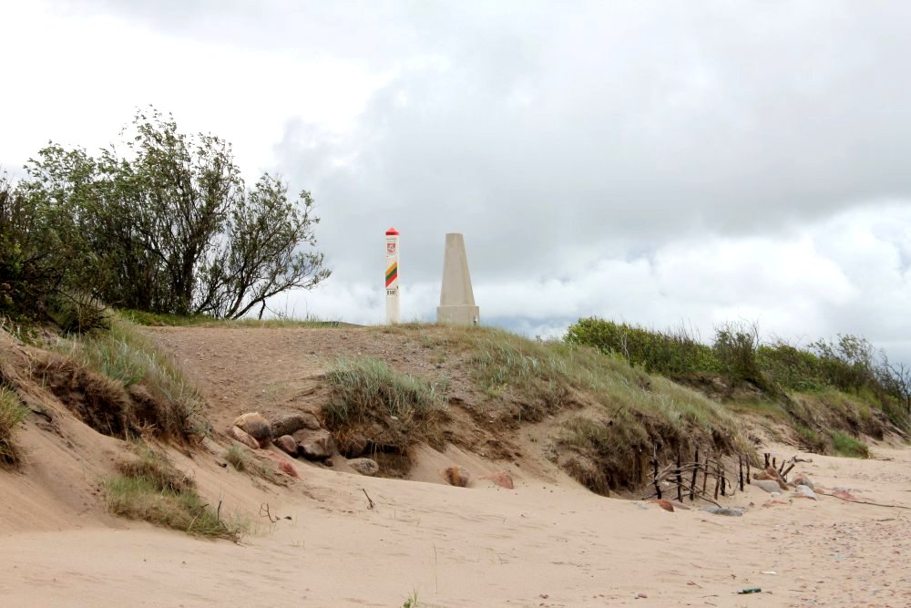
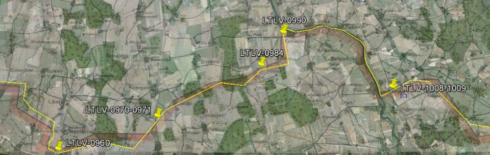
| LTLV-0960 |
56° 14' 56"N 24° 07' 18"E |
262 — 263 |
434 |
58 |
|
|
Didysis Plonėnas, LT / Lībieši, LV |
Yes |
|
|
| LTLV-0970-0971 |
56° 15' 44"N 24° 11' 38"E |
265 — 266 |
437 |
59 |
|
|
Puodžiūnai, LT / Krievgaļi, LV |
Yes |
Yes |
|
| LTLV-0984 |
56° 16' 52"N 24° 15' 53"E |
268 — 269 |
438 |
60 |
|
|
Kiemėnai, LT /
Uzvara, LV |
No |
Yes (2) |
Pre-Schengen border crossing point closed
after Schengen. |
| LTLV-0990 |
56° 17' 47"N 24° 17' 11"E |
271 — 272 |
438-439 |
61 |
|
|
Kamardė, LT / Paliepas, LV |
No |
|
Pre-Schengen border crossing point closed
after Schengen. |
| LTLV-1008-1009 |
56° 16' 29" N 24° 21' 55" E |
287 |
442/442 |
62 |
|
|
Saločiai, LT / Grenctāle, LV |
Yes |
Y (2) |
|
| LTLV-1021-1022 |
56° 15' 29" N 24° 27' 15" E |
291 — 292 |
447-448 |
63 |
|
|
Kubiliūnai, LT / Tunkūni, LV |
No |
|
The boundary runs next to the highway for
about 411 m. |
| LTLV-1037 |
56° 17' 21"N 24° 33' 56"E |
297 |
449 |
65 |
|
|
Joneliai, LT /
Brunava, LV |
Yes |
|
|
| LTLV-1079 |
56° 22' 41"N 24° 38' 41"E |
3171 — 3181 |
505-506 |
68 |
|
|
Germaniškis, LT / Skaistkalne, LV |
Yes |
Yes
(2) |
|
| LTLV-1189-1191 |
56° 10' 41"N 25° 08' 44"E |
379 |
567 |
83 |
|
|
Kvetkai, LT /
Pilskalne, LV |
Yes |
|
|
| LTLV-1210-1211 |
56° 09' 38"N 25° 16' 47"E |
382 — 383 |
574-575 |
86 |
|
|
Suvainiškis, LT / Nereta, LV |
Yes |
|
|
| LTLV-1256 |
56° 09' 24"N 25° 30' 27"E |
396 |
579 |
89 |
|
|
Ilzenbergas, LT / Muitnieki,
LV |
Yes |
|
|
| LTLV-1292-1293 |
56° 07' 35"N 25° 41' 05"E |
417 — 418 |
583-584 |
94 |
|
|
Juodupė, LT /
Aknīste, LV |
Yes |
|
|
| LTLV-1347-48 |
56° 00' 30"N 25° 50' 56"E |
438 |
590 |
99 |
|
|
Bukūnai, LT |
No |
|
Pre-WWII crossing point. |
| LTLV-1357-1359 |
55°59' 59"N 25°53' 50"E |
440 — 441 |
590 |
99 |
LT+LV |
|
Obeliai, LT / Subate, LV |
Yes |
Yes (2)
|
|
| LTLV-1404-1405 |
55° 56' 40"N 26° 02' 45"E |
458 |
599 |
102 |
LT+LV |
LT+LV |
Obeliai, LT /
Eglaine, LV |
Railway crossing point |
|
Two pre-WWII boundary markers painted in
national colours were left here. |
| LTLV-1408 |
55° 55' 49"N 26° 03' 50"E |
460 |
599 |
103 |
|
|
Kamariškiai, LT /
Paberži, LV |
Yes |
|
|
| LTLV-1434 |
55° 52' 18"N 26° 09' 39"E |
466 — 467 |
601 |
105 |
|
|
Raudinė, LT /
Cielavinas, LV |
Yes |
|
|
| LTLV-1453-1454 |
55° 49' 51"N 26° 13' 55"E |
470 |
601 |
106 |
|
|
Stelmužė, LT /
Rauda, LV |
Yes |
|
|
| LTLV-1480-1482 |
55° 44' 41"N 26° 18' 34"E |
477 |
603 |
109 |
LT+LV
|
|
Smelynė, LT /
Medumi, LV |
Yes |
Yes (3) |
|
| LTLV-1507 |
55° 42' 40"N 26° 24' 28"E |
488 |
614 |
111 |
|
|
Mateikiškė, LT / Grendze, LV |
No |
Yes |
Former LTLVPL / Lithuanian - Latvian -
Polish) tripoint, near the last
Latvian-Lithuanian pre-WWII border marker. |
| LTLV-1521-1522 |
55° 42' 11"N 26° 28' 03"E |
|
|
|
|
|
Turmantas, LT / Kurcums, LV |
Railway crossing point |
|
Border adjustment in 1995. |
| LTLV-1554-1559 |
55° 40' 31"N 26° 35' 00"E |
|
|
|
|
|
Tilžė, LT /
Demene, LV |
Yes |
|
|
| BYLTLV |
55° 40' 50"N 26° 37' 50"E |
|
|
|
|
|
Liudevinova (BY), Liudvinavas (LT),
Ludvinova (LV) |
No |
|
Present Byelorussian - Latvian - Lithuanian
tripoint. |
|
Footnotes: |
|
1:
(LT) = Only remains of a Lithuanian concrete marker were found.
In total 10 out of 20 (10 pairs) pre-WWII concrete
markers were found, as well as remains of 2
more. |
|
2:
=
International border crossing (1996 - 2007).
= Border crossing for local citizens only (1996-2007). |